The rise of the mega-constellations has set a new precedent in orbital congestion, simply as a result of the increased number of satellites. But that is only part of the story: it’s also an issue of regulation and planning which, as Stuart Eves explains, includes the esoteric topic of frequency coordination.
For the past decade or so, the US military has pointed out that the space environment is increasingly “Congested, Contested and Competitive”. Although it was always recognised that commercial space activities contributed to the “three Cs”, the implicit focus from a US military perspective has always been on the extent to which other nations could challenge US supremacy in space.
It is true that the military threats to space have indeed increased as India, Russia, and China have all tested ASAT systems over this period. However, since 2010 it has become increasingly apparent that far more congestion, contention and competition has arisen in near-Earth space as a result of the activities of commercial companies as they launch their mega-constellations.
 OneWeb solution to limiting radio interference.
 Diagram showing the increasing probability that a user of the Kuiper system will encounter a Starlink satellite in an adjacent part of the sky.
Radio interference
As the number of mega-constellation satellites builds, there is an increasing probability that they will interfere with each other
Although the potential dangers of physical collisions between space objects and the contingent increase in orbital debris is a broad topic of interest across the space community, the issue of radio frequency interference (RFI) has been less well covered. The radio frequency spectrum is coordinated at a global level by the International Telecommunication Union (ITU) and discussed at the regular World Radio Conference (WRC), which produces recommendations and, eventually, regulations to coordinate frequency use and limit interference.
A principal source of the potential difficulties for current satellite systems is that the radio spectrum the mega-constellations wish to use is already in use by existing geostationary (GEO) satellites. A potential scenario, therefore, is that as the constellation satellites orbit the planet in low Earth orbit (LEO), they fly through the beam of a GEO satellite, transmitting on the same frequency, and cause interference to users on the ground below. For geometric reasons, this is only an issue when the LEO satellites are relatively close to the equator, but since they all cross the equator twice on each revolution it remains an issue.
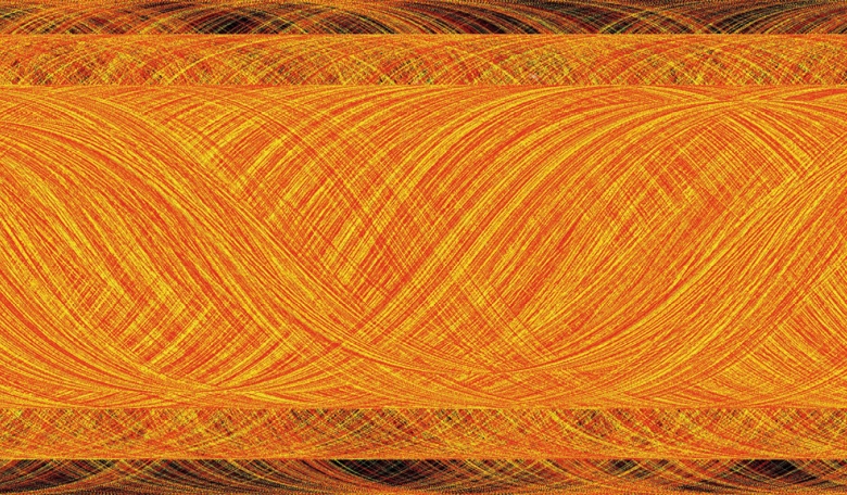
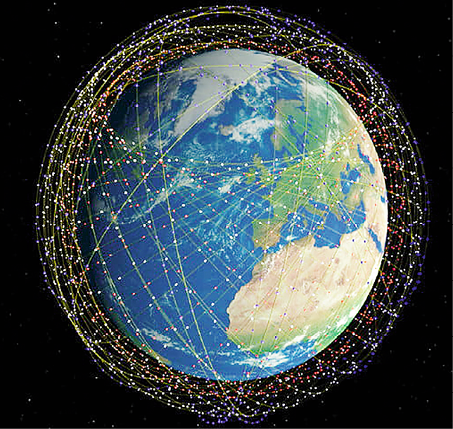 Illustration of the Starlink constellation highlights the convergence of satellites at latitudes close to its orbital inclination of 53 degrees
The proposed solutions to this problem vary. OneWeb has devised an approach called ‘progressive pitch’ in which its Arrow platforms will deliberately change their orientation with respect to the Earth when near the equator, such that a LEO satellite which is ‘in the beam’ of a GEO satellite is never attempting to transmit into the same geographical region on the ground. This is somewhat inconvenient, but probably represents a workable solution.
The Starlink solution is somewhat simpler as it proposes to ‘switch off’ satellites when they are at risk of creating interference to an existing GEO mission. The final Starlink constellation will, we understand, comprise thousands of satellites with overlapping footprints, so it is theoretically possible that they will be able to maintain continuous coverage for the user community despite the fact that some of their satellites are temporarily switched off. It is of course true that a satellite that is switched off is, inevitably, a satellite which is not generating revenue, and that repeated switching of components can lead to reliability issues on satellites, but the Starlink engineers will presumably have factored these considerations into their designs.
In the case of the Kuiper constellation, the solution is to exploit the fact that the satellites will be equipped with sophisticated multi-beam antennas. The satellites will calculate when they are in a location that might cause interference and avoid transmissions which could cause inconvenience to other systems. This implies a very robust orbit determination capability, a very complete and up-to-date catalogue of the extant GEO satellite transmissions and a pretty phenomenal piece of network management software… but the financial resources of Amazon are clearly very large.
Existing GEO systems aren’t the only potential sources of RF contention though. As the number of mega-constellation satellites builds, there is an increasing probability that they will interfere with each other. It should be reasonably clear that, even from LEO, hundreds or even thousands of satellites are not needed simply to provide users with a line of sight to a satellite. The reason why the mega-constellations are so large is that each satellite is only designed to provide services in a relatively small region immediately beneath its ground track. The sizes of these satellite footprints also dictate the range of angles over which the user terminals must operate in order to maintain contact with the constellation.
One of the ‘issues’ being hotly debated by the Kuiper and Starlink constellations is the decision by the latter to change the altitude and the elevation angles used by their satellites. Starlink was originally planning to operate its satellites at 1150 km with user elevation angles of 40 degrees. In order to improve the latency of the constellation (i.e. reduce signal delay), SpaceX took a late decision to lower its operational altitude to 550 km and also lower the user elevation angles to 25 degrees.
As the diagram oin the prvious page shows, this increases the probability that a user of the Kuiper system will encounter a Starlink satellite in an adjacent part of the sky. Kuiper has claimed that the increase is as much as 250 percent, but until it begins to deploy its constellation, Starlink will presumably be able to operate with impunity.
Impact on astronomy
Aside from the potential problems in the radio frequency domain, the mega-constellations are also creating issues at optical wavelengths
Then, of course, there is the possibility that the mega-constellation satellites will make life difficult for the radio astronomy community. As mandated by the World Radio Conference in 2019, mega-constellation satellites must be equipped with filters that specifically aim to protect the radio telescopes which operate between 10.6 and 10.7 GHz. Clearly, it is hoped that the active transmissions from satellites can be managed, but a rather more contentious issue is the possibility that the increased amount of mega-constellation hardware in Earth orbit will cause inadvertent interference simply by being there. An experiment performed by the Murchison radio telescope array in Australia has demonstrated the fact that terrestrial radio signals (including FM radio stations) can be detected by reflection from objects in LEO. Now admittedly, the target object in the Australian experiment was the International Space Station (ISS), which is by far the largest man-made object in space, but the implications are serious.
Estimates of the sensitivity of the radio astronomy community’s flagship project, the Square Kilometre Array, suggest that it will have sufficient sensitivity to detect objects as small as 0.5 metres in size via this so-called ‘bi-static reflection’ technique. Since all the communications mega-constellations plan to use satellites larger than this, this raises an important question: “Is anywhere now truly ‘radio-quiet’?”.
Aside from the potential problems in the radio frequency domain, the mega-constellations are also creating issues at optical wavelengths. One issue that has received extensive coverage is the fact that Starlink’s satellites are creating ‘artefacts’ in astronomical observations.
Technically, this has always been a possibility, but when satellite numbers were lower, and telescope fields of view were smaller, the problems were manageable. Now, however, new instruments such as the Rubin Observatory are deliberately widening their fields of view to enable more efficient searches for targets such as near-Earth objects (NEOs) and exoplanets. With the simultaneous increase in satellite numbers, the chances of a satellite entering a telescope’s field of view and corrupting its image are much higher.
The exact risk we face from NEOs is uncertain, since our census of the smaller objects that might threaten us is still very incomplete, but it would be rather tragic if an opportunity to provide a warning of an incoming hazard was missed because a mega-constellation satellite got in the way.
To its credit, Starlink has recognised the issue and sought to address it by conducting experiments to reduce the reflectivity of its antennas, introducing sun-visors to shadow highly reflective components and by changing the attitude of their satellites in the orbit-raising phase of the mission. Ironically, however, one of its more effective measures is the lowering of the orbital altitude, since this cuts the time that satellites spend in twilight conditions (where the ground is in darkness but the satellites are still illuminated by the Sun).
Other constellations, such as OneWeb, which are still planning to orbit at 1200 km, will be visible for much longer periods, and in the (Northern) summer months will be visible all night to telescopes located in the Northern hemisphere. OneWeb has stated publicly that it wishes to utilise space responsibly, but to date it has not announced any concrete measures to mitigate the light pollution that its satellites will cause.
Unregulated environment
Perhaps it is time for astrodynamicists to play a greater role in advising licensing authorities about the safety of a given constellation design
Another issue highlighted by Starlink’s revised orbital configuration is that, at present, physical space in LEO is not regulated. Unlike the RF domain, where filings are coordinated internationally with the aim of avoiding interference, no equivalent restrictions are placed on satellite orbits to avoid potential conjunctions. Admittedly, Starlink’s revised filing with the FAA in the US was scrutinised in terms of orbital altitude to avoid contention with Kuiper, and an accommodation was reached to try to keep the two constellations apart, but there is no a priori reason why other international jurisdictions could not license other operators to occupy these altitudes also. Hence, LEO is an ‘unplanned environment’ from an orbital perspective.
Unfortunately, there is every reason to believe that congestion in very low orbits may increase. As anyone who has studied the financial markets will know, the latency of financial transactions is crucial. One of the major ‘selling points’ of constellations at altitudes of around 650 km and lower is that they can potentially improve on the signal delay of fibre-optic cables that currently move much of the globe’s financial information. This is because the effective speed of light through fibre-optic glass is only about two thirds that in a vacuum.
We could, therefore, see a ‘race to the bottom’ where, in this case, the desire is to operate in the lowest viable orbits in order to minimise the time it takes to move data between financial centres using satellites equipped with inter-satellite links (such as Starlink and Kuiper). This sort of physical congestion is dangerous, as it risks collisions of the sort that afflicted the Iridium constellation in 2009, and which has subsequently forced the ISS to make evasive manoeuvres to avoid the debris which was generated.
Even where separate orbital altitudes are agreed for operations, there are still risks when satellites are transiting from their initial parking orbits up to their operational altitudes. An example of this occurred recently, when OneWeb and Starlink satellites were identified as heading for a conjunction, and the two companies had an extended disagreement in the press over the process (or lack of one) to resolve the issue.
One feature of the Starlink system design that was highlighted during this incident was its use of an automated manoeuvre system. With so many satellites to manage, Starlink not unreasonably decided to take human operators out of the loop and rely instead on a computer-based system for constellation maintenance. This has obvious benefits for managing the Starlink system itself, but is a potential hindrance when satellites from a different constellation are involved.
So perhaps it is time for astrodynamicists to play a greater role in advising licensing authorities about the safety of a given constellation design before the satellites are launched. When Iridium first publicised its original constellation back in the early 1990s, the inclinations of all its orbital planes were specified to be 90 degrees, and at the same altitude. It was pointed out that this would result in satellites converging on the same points in space over the north and south poles, increasing the risk of collisions, and Iridium subsequently reduced the orbital inclinations to lower the risk. OneWeb’s orbital design appears to have undergone a very similar evolution in more recent times. Nevertheless, it remains the case that all the mega-constellation operators are proposing to use circular orbits and expect to place many tonnes of material into narrow orbital shells around the Earth.
As Don Kessler pointed out as long ago as 1978, increasing the density of material above a certain threshold in specific orbits can create a situation (later known as the Kessler Syndrome) in which a self-sustaining chain of collisions can take place. Obviously, all the mega-constellation operators recognise this risk, and are planning to deorbit their satellites at the end of their lives rather than leave derelict hardware in operational orbits. The rogue factor here, however, is the existing debris population.
Due to limitations in our ability to detect and track small debris in the 1-10 cm size range, the number of such objects is very uncertain, although both NASA and ESA estimate the populations to be in the hundreds of thousands. There is currently no regulatory requirement for operators to conduct a debris survey when selecting orbital altitudes, although it is encouraging that OneWeb’s choice of 1200 km was influenced by the fact that it is a ‘local minimum’ in the tracked population. However, due to the varying orbital lifetimes generated by differences in object size, ballistic coefficient and response to solar radiation pressure, there is actually no guarantee that this altitude also represents a minimum in the untracked population.
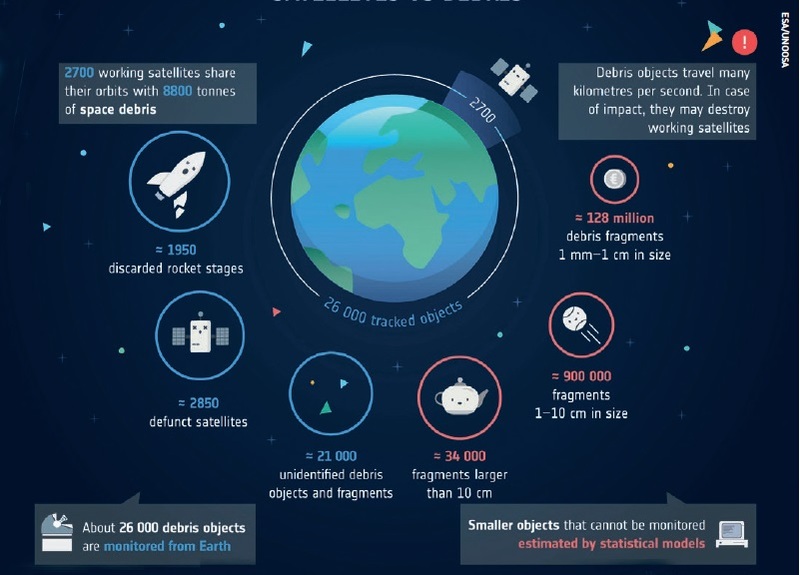
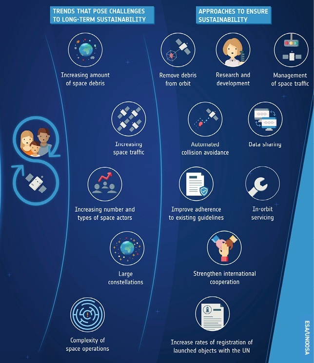 Long term space sustainability.
Call for control
Kuiper and Starlink constellations will face a steady ‘rain’ of small debris objects descending through their orbital space
At their very low operational altitudes, the Kuiper and Starlink constellations will face a steady ‘rain’ of small debris objects descending through their orbital space as a consequence of the drag created by the Earth’s atmosphere. Perhaps, therefore, it is time to consider the potential benefits of using mildly eccentric orbits. They would not compromise the constellation coverage patterns or generate inconvenient Doppler shifts on signals, but would be sufficient to spread the constellation mass over a much larger volume of space, thereby lowering the collision risk.
Actuarial calculations by the insurance community, with lower premiums for operators adopting such risk mitigation strategies, might help to encourage such behaviours. Even then, some constellation designs create intersection regions where many satellite planes converge, and it is only prudent to ask whether this is a sustainable idea in the long-term. The design of the Starlink constellation, for example, highlights the convergence of satellites at latitudes close to its orbital inclination of 53 degrees.
Humans already derive enormous benefits from satellite systems, and will potentially see even more advantages from mega-constellations in the future. If, however, Earth orbit remains uncoordinated, under-regulated and unplanned, these improvements are likely to be unsustainable and short-lived. We need an international system of Space Traffic Control - and we need it NOW!
About the author
Dr Stuart Eves runs a space consultancy company (SJE Space), having previously spent 16 years with the UK Ministry of Defence and 14 years with Surrey Satellite Technology Limited (SSTL). During his time with the MOD, Stuart initiated the TopSat programme, which established a new world record for ‘resolution per mass of satellite’. He has recently published Space Traffic Control, a book which describes the measures needed to maintain the space environment and protect satellites from both natural hazards and man-made threats such as space debris. Stuart has an MSc in Astrophysics, a PhD in satellite constellation design, and has been a fellow of both the Royal Astronomical Society and the British Interplanetary Society for more than 25 years.


