Space-based technology that enables charities and local authorities to deliver vital support to people who need help as a result of the COVID-19 pandemic has been successfully piloted in the UK.
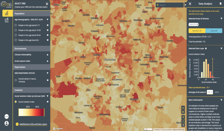
Called Isolation Plus, the tool uses space data and ground-based information to generate maps which identify potentially at-risk communities that may be off the radar. Support organisations – such as food banks and mental health services – use this to reach out to people in emerging vulnerable areas and provide them with early assistance.
The pilot – in which the platform was refined and put to practice by several organisations including Support In Mind Scotland and Voluntary Action Orkney – is the first step to making the tool commercially available across the UK.
Backed by ESA and the UK Space Agency, Isolation Plus was developed by Scotland-based space-tech firm Astrosat in collaboration with London-based company Lanterne.
During the COVID-19 crisis, charities and local authorities have been working hard to meet the enormous task of providing assistance to those known to be at risk.
As coronavirus restrictions begin to lift in the UK, these efforts are now helping society recover from the pandemic. But a growing number of previously independent people – known as the ‘hidden vulnerable’ – are also finding themselves in need of support.
Jill Morris, business analyst at Astrosat and project manager for Isolation Plus, said: “The Isolation Plus project has been eye-opening for many people in terms of the diversity of applications for Earth observation data. With the support of ESA and the UK Space Agency, we have leveraged this resource to provide real value to organisations who reach out to help people in their communities.”
Isolation Plus combines several data types, including census data and insights on consumer behaviour. Earth observation information about infrastructure, availability of transport, social isolation and access to green spaces is also integrated.
This is used to build a map of vulnerability on the community level, which takes into account susceptibility to health issues, likelihood of isolation, risk of poverty, and the effect of the environment on people’s wellbeing.
The platform also integrates information on the crowdedness of public spaces such as supermarkets, which enables charities to direct outreach efforts and services safely. During the pilot, 14 organisations used the tool to help local communities.
Jim Hume, director of policy and public affairs at Support In Mind Scotland, said: “The COVID-19 crisis has intensified the pressure on marginalised communities with important impacts on mental health. Isolation Plus is a valuable tool that has enabled us to identify at-risk rural communities and then direct prioritised actions needed to develop place-based and people-centred approaches to support them.”
Arnaud Runge, ESA medical engineer and technical officer of the Isolation Plus project, said: “Space-based services are often wrongly perceived as expensive solutions, only reserved for an elite able to afford them. With Isolation Plus, we successfully demonstrated that space can contribute to help vulnerable people in a sustainable way. This is our best possible reward.”


